Raman-shifted Eye-safe Aerosol Lidar (REAL)
Field-transportable Scanning Atmospheric Lidar Research Facility
What is it?
The REAL is a field-transportable, scanning atmospheric aerosol lidar. It currently consists of two shipping containers on a 48-foot-long air-ride flatbed trailer. The front container houses the instrument and the rear container is a storage and control room. We contract with independent truckers to move it field experiments. It is used to conduct basic and applied atmospheric research. When not deployed in the field, it resides on the Chico State campus and can be operated for research and educational purposes.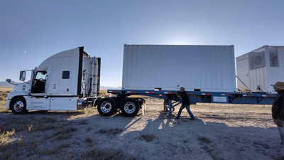
How does it work?
The REAL uses very short (6 ns at 10 Hz) pulses of invisible, eye-safe, near-infrared electromagnetic radiation in much the same way as weather radars use pulses of microwave radiation. The wavelength of near-infrared radiation, approximately 10,000 times shorter than microwaves, makes the lidar sensitive to suspended particulate matter (aerosol particles: dust, smoke, pollen, and haze particles). Five refereed journal articles (1, 2, 3, 4, 5) and two US patents (7583364 and 7580127) describe the key aspects of the REAL. A full list of publications that include meteorological applications of the instrument can be found here.
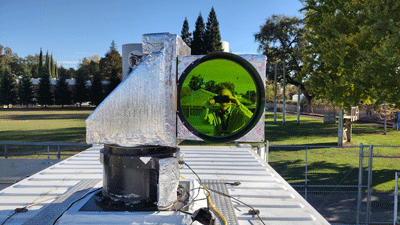
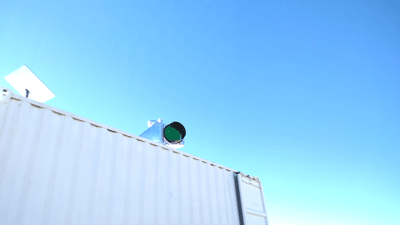
Just as radars can tell meteorologists where it is raining and snowing, the lidar reveals the distribution of particulate matter in the atmosphere. Whereas many radar use a moving dish antenna, the REAL uses a rooftop "beam steering unit" (BSU, or "scanner") to direct the laser pulses across the sky. The glass window to the BSU occasionally has a green appearance due to the thin-film anti-reflection coating for 1.5 microns wavelength.
What can it see and how far?
Because the lower atmosphere almost always has a lot of particulate matter in it, the REAL can "see" something almost everyday, except when foggy or during intense precipitation. On a normal fair weather day in Dixon or Chico, CA, it can usually obtain useful data from 1 - 3 km range. When smoke or haze is present sometimes 4 - 8 km.
The images, such as the one above, can show the depth of the atmospheric boundary layer, and the location of aerosol plumes. By applying computer vision algorithms to horizontal scans, the REAL can determine the vector wind field as shown below.
_400x349.png)
Click here for an example of a time-lapse animation of the vector wind fields.
What is unique about it?
When REAL was new (2004), its wavelength of 1.5 microns made it unique. Nowadays many lidars operate at that wavelength. However, several other aspects of the REAL make it unique. Most modern lidars transmit very weak (<1 mJ) laser pulses at a high pulse rate (>1 kHz), and integrate backscattered power over time to make up for the low energy pulses. The REAL transmits high energy pulses (>125 mJ) at a low pulse rate (10 Hz) and no integration of backscatter is required in time. (DOD versions of the REAL operated at 20 Hz and laboratory versions at 50 Hz.) In addition, the REAL produces high spatial resolution data. So, its primarily uniqueness is in producing high signal-to-noise-ratio, high temporal (0.1 s in time), and high spatial resolution (1.5 m in range) data.In addition to the photonics aspects of the REAL, it is unique in that it is a large field-transportable facility. Currently, REAL is laid out on a large optics table and occupies most of a 20-foot shipping container. This luxury makes training and maintenance easier, and invites experimental work. The lab container is insulated, HEPA filtered, climate controlled, networked, and can operate continuously in all weather conditions.
What type of lidar it is?
The REAL is not a Doppler lidar and it is not Raman lidar. Doppler lidars employ heterodyning to measure the radial velocity of scatterers. Raman lidars detect the Raman scattering of water vapor in the atmosphere. The word Raman in REAL refers to stimulated Raman scattering that occurs in the transmitter to generate laser pulses at 1.5 microns. The REAL transmits very pure linearly polarized pulses and utilizes a polarization beam splitter cube in the receiver for relative polarization measurements of aerosol backscatter. So, the REAL is a scanning elastic backscatter polarization lidar.Who made it and who owns it?
The REAL was developed by Shane Mayor, Scott Spuler, and Bruce Morley at the National Center for Atmospheric Research (NCAR) between 2002 and 2007. In 2008, it was long-term loaned to CSU Chico until 2018 when it was transferred to Chico State Enterprises (CSE). From 2008-2022 it resided at the Chico State University Farm. In 2022, it was moved to the main Chico State campus. The vast majority of funding to operate the REAL comes from the National Science Foundation's Physical and Dynamic Meteorology Program.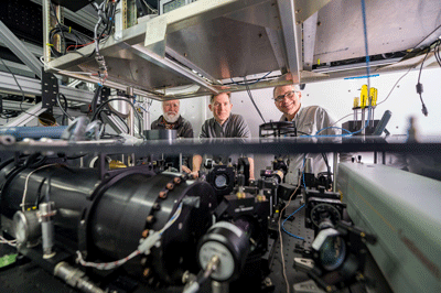
What have we learned?
Science is based on observations and measurements, and observations and measurements require instruments. Much of what we have learned over the years is about how to build, maintain, and deploy a complex instrument capable of making cross-sectional images of the clear atmosphere and, in particular, its movement through computer vision methods (1, 2, 3). Other specific results about atmospheric phenomena are described in the following journal articles (1, 2, 3, 4, 5, 6, 7). A comprehensive list of our publications can be found here.Tech Transfer
The intellectual property of the REAL is owned by the University Corporation for Atmospheric Research (UCAR) and was freely shared with the Department of Defense (DOD) for applications in national security. Versions of the REAL were made by ITT Corporation for the DOD for use near Washington DC and Dugway, Utah. The Typhoon software, developed subsequently by Pierre Dérian, is joint intellectual property of INRIA and Chico State Enterprises and is available for licensing.
System specifications of the original REAL
- Wavelength: 1.543 microns (Near-IR, Telecommunications C band)
- Pulse energy: originally 170 mJ (typically 130 mJ)
- Pulse rate: 10 Hz
- Pulse duration: 6 ns
- Beam diameter:
- At 0.0 km range: 66 mm (based on 1/e2 points in beam profile)
- At 1.6 km range: 0.5 m
- At 6.0 km range: 1.5 m
- Beam divergence: 0.12 mrad (half-angle)
- Receiver field-of-view: 0.54 mrad
- Telescope diameter: 40 cm
- Detector type: InGaAs APD
- Analog to digital converter sampling rate: 100 MHz
- Analog to digital converter resolution : 14 bits
If you have a question about the REAL, please write to Shane Mayor.